|
|
| Line 1: |
Line 1: |
| == Summary ==
| |
| {{Information
| |
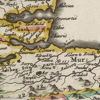
| | description = The area of Moray Firth including the [[Nairn Parish, Nairnshire|parish of Nairn]] and [[Kilravock Castle|Kilravock]] from the ''Scotia regnum cum insulis adjacentibus'' included in [[Blaeu Atlas of Scotland|Blaeu's atlas]] of 1654.
| |
| | source = {{Blaeu atlas full |map_title=Scotia regnum cum insulis adjacentibus / Robertus Gordonius a Straloch descripsit.|translated_map_title=Robert Gordon of Straloch described the kingdom of Scotland with its adjacent islands|url=https://maps.nls.uk/view/00000383#zoom=6&lat=3911&lon=3745&layers=BT|zoom_section=Nairn and Kilravock|today=4 Jan 2022}}
| |
| | date = 4 Jan 2022
| |
| | author = Own work.
| |
| | permission = Map is licensed [[Creative Commons#Attribuite|Creative Commons attribute]] by the [[National Library of Scotland#Maps|National Library of Scotland]]. This image is licensed [[Creative Commons#Attribute Non-Commercial No-Derviatives|Creative Commons attribute non-commercial no-derivatives]].
| |
| | other_versions =
| |
| | additional_information =
| |
| }}
| |
|
| |
|
| == Licensing ==
| |
| {{cc-by-nd-4.0}}
| |
|
| |
| [[Category:Nairnshire maps]]
| |
Revision as of 01:16, 21 October 2025
File history
Click on a date/time to view the file as it appeared at that time.
| Date/Time | Thumbnail | Dimensions | User | Comment |
|---|
| current | 01:16, 21 October 2025 |  | 200 × 200 (15 KB) | Redheadkelly (talk | contribs) | |
You cannot overwrite this file.
File usage
The following page uses this file:
This file contains additional information, probably added from the digital camera or scanner used to create or digitize it.
If the file has been modified from its original state, some details may not fully reflect the modified file.