

File:Nairn-and-Kilravock-1654.jpg
More actions


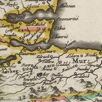
Nairn-and-Kilravock-1654.jpg (200 × 200 pixels, file size: 15 KB, MIME type: image/jpeg)
Summary
| Description |
The area of Moray Firth including the parish of Nairn and Kilravock from the Scotia regnum cum insulis adjacentibus included in Blaeu's atlas of 1654. |
|---|---|
| Source |
Blaeu, Joan, ed. (1654). Scotia regnum cum insulis adjacentibus / Robertus Gordonius a Straloch descripsit [Robert Gordon of Straloch described the kingdom of Scotland with its adjacent islands] (Map). Blaeu Atlas of Scotland (in Latin). Cartography by Timothy Pont and Robert Gordon. Amsterdam: Blaeu. § Nairn and Kilravock. Retrieved 4 Jan 2022 – via National Library of Scotland.CS1 maint: unrecognized language (link) |
| Date |
4 Jan 2022 |
| Author |
Own work. |
| Permission (Reusing this file) |
Map is licensed Creative Commons attribute by the National Library of Scotland. This image is licensed Creative Commons attribute non-commercial no-derivatives.
|
Licensing
File history
Click on a date/time to view the file as it appeared at that time.
| Date/Time | Thumbnail | Dimensions | User | Comment | |
|---|---|---|---|---|---|
| current | 01:16, 21 October 2025 | | 200 × 200 (15 KB) | Redheadkelly (talk | contribs) |
You cannot overwrite this file.
File usage
The following page uses this file:

