William Ross Sr. (before 27 January 1765 – c. 1811) was granted two tracts of land on Rocky River, Mecklenburg County, North Carolina, in the 1780s, and is documented in Mecklenburg and Cabarrus County deed and marriage records through 1793. He is documented under substantially fuller records in Montgomery and Stewart County, Tennessee, from 1800 until his death about 1811, where he is the father of eight documented children, including William Ross Jr. and Charles T. Ross. This article combines what were, until recently, two separate wiki articles treating the North Carolina and Tennessee records as possibly unrelated individuals; see Identification with the Rocky River grantee below for the evidence connecting them.
DNA evidence
Y-DNA
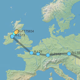
Migration path of Y-DNA haplogroup R-FT424248
One descendant of Eli Ross has done Y-DNA testing and he is a match to Y-DNA R Haplogroup - Family 01. Recent research by descendants of Eli Ross has determined that he is most likely the grandson of this William Ross though his son Charles T. Ross. If this is the case, then the Y-DNA haplogroup of this line is currently R-FT424248.
Several descendants of James Ross of Monroe County also fall into this haplogroup branch. Y-DNA is estimating that the most recent common ancestor shared by these FT424248 men lived circa 1790 CE, but potentially anytime between 1650 CE and 1890 CE. The birth date of this William Ross is estimated to be circa 1765 or earlier. And the birth date of James Ross is estimated to be circa 1750. It's not clear, then, how these two lines could be connected.
R Haplogroup - Family 01 is a large group that shares a common ancestor who lived circa 1100 CE. It breaks into three main branches, two of which contain Ross kits and the other containing a combination of Ross and Rose kits. Kits descended from Hugh Rose, 8th of Kilravock, fall into the Ross and Rose branch. It is currently assumed that this branch represents the descendants of Hugh Rose, 1st of Kilravock, who appeared in the Highlands in the 13th century. It was thought by historians several centuries ago that his ancestors came from Rots in Normandy during the Conquests with William's brother Odo who was bishop of Bayeux.[1][2]
The Ross branches are still unknown. There is legend that Kilravock descends from, or is kin to, Ross of Halkhead, Lords of Parliament. It is entirely possible that one or both of the Ross branches descend from Ross of Halkhead, but there is not yet Y-DNA evidence to confirm this. They could also potentially represent descendants of another family that came from Normandy during the Conquest. There were several that settled in England including Ros of Kent and Roos of Helmsley.[1]
Haplogroup R-FT424248 falls into the larger of the two Ross branches. This means that this line is not expected to be a direct descendant of Rose of Kilravock. More research is needed to determine the identity of these two Ross branches.
This Kilravock group is descended from R1b-L21, known as the Atlantic Celtic branch. These peoples had reached what is now Germany by 2500 BCE and had crossed over to Britain by about by 2100 BCE.[4] This is not to say that the Kilravock line made its way to Britain 4,000 years ago and remained there. It's entirely possible that there were additional migrations that placed them back in the area of Normandy at the time of the Conquest as is postulated by later historians. While Y-DNA testing has not yet refuted this theory, it also has not confirmed it. More testing is needed.
Autosomal DNA
Biography
Early life
No birth record has been located for William Ross Sr. His birth is estimated as before 27 January 1765, on the assumption that he was of legal age (21) by the date of his first North Carolina land grant entry.[5]
Mecklenburg and Cabarrus County, North Carolina, land records, 1786–1793
Loading map...
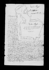
William Ross Sr. first appears in North Carolina land grant records in 1786, when he entered two tracts on Rocky River, Mecklenburg County: a 622-acre tract on "the waters of Rockey river" (entry 992, 27 January 1786) and a 97-acre tract "on the North side of Rocky River" (entry 993, 27 June 1786), both surveyed 28 April 1787 and issued to him on 26 November 1789 as grants No. 3681 and No. 3700.[5][6] The 622-acre grant adjoined the lands of George Tucker, David Cagle, John Hartsell, Douglass Winchester, Henry Price, and William Winchester; the 97-acre grant adjoined John Ashley and John Finney.[5]
On 28 August 1789, Robert Smith conveyed William Ross a further 100 acres in Mecklenburg County adjoining John Finney, Peter Rape, and John Bigger; this deed was proved in court in January 1792.[7] In January 1792, William Ross conveyed 869 acres on Rocky River, Mecklenburg County, to Daniel Bean (also spelled Bain, Baine, or Bayne) — his own son-in-law, married to his daughter Sarah since December 1789 (see Marriage and family in Mecklenburg County below).[8] On 19 April 1793, Daniel Bean, of Cabarrus County (formed from Mecklenburg County in 1792), conveyed four tracts totaling 869 acres — the same lands, including the original 622-acre grant No. 3681 — to "William Ross, Junior," of Cabarrus County, for £400; the deed was witnessed by David McKinley Sr. and William Ross [Sr.], and acknowledged in open court by Daniel Bean in October 1793.[9] This last-documented appearance — witnessing his own son-in-law's conveyance of his former land to his own son — is the final trace of William Ross Sr. in the Mecklenburg/Cabarrus County record.
Marriage and family in Mecklenburg County
On 29 December 1789, William Ross's daughter Sarah Ross married Daniel Bane (Daniel Bain) in Mecklenburg County, North Carolina, with William Ross himself signing as bondsman for the marriage license.[10] This marriage record is the documentary link connecting the Rocky River land grantee to the William Ross Sr. otherwise documented only in Montgomery and Stewart County, Tennessee, from 1805 onward — see Identification with the Rocky River grantee below.
Montgomery and Stewart County, Tennessee, land records, 1800–1811
The earliest documented appearance of William Ross Sr. in Tennessee is the 1800 Montgomery County tax list: taxed by Charles Stewart in Capt. Charles Stewart's Company, William Ross Sr. was assessed for 1,116 acres and four enslaved persons, and William Ross Jr. was separately taxed as a single white poll — the two appearing together on the same tax list, consistent with father and son.[11] By about 1803, when Stewart County was organized from Montgomery County, William Ross Sr. was still resident in the area.[12]
On 17 February 1805, William Ross Sr., of Montgomery County, Tennessee, granted to his son William Ross Jr., "for and in consideration of the love and regard he has for his son," a tract of land on the Little West Fork of the Red River, beginning at Joshua Ross's southeast corner; the deed was witnessed by Glidwell Killebrew and David Enloe.[13][14]
On 18 July 1806, Samuel Allen sold Glidwell Killebrew, both of Montgomery County, a 300-acre tract on the Little West Fork of the Red River adjoining land Allen had sold to David Dupuy, described in the deed as "son-in-law of William Ross Sr.," and part of three tracts originally granted to William Ross Sr. and William Whitehead.[15][14]
On 7 March 1807, William Ross Jr. signed a bond to his father in the sum of $2,000, conditioned on the understanding that if he ever made a claim against his father's estate, he would first pay $1,000 with interest before drawing his equal share as a child of William Ross Sr.[16][17]
On 2 September 1807, William Ross witnessed a deed of David Enloe to James Ross for 29 acres on the west fork of the Red River.[18][19] Later that month, on 18 September 1807, William Ross Sr. sold Thomas Blakeney 200 acres on the Little West Fork of Red River, part of a tract originally granted to the heirs of Clement Smith, witnessed by James Lockert and Lewis Elliott.[20][19]
On 29 February 1808, William Ross Sr. and Thomas Watson sold John Shelby 110 acres on Flat Lick Fork of the Little West Fork of Red River, part of a 640-acre tract the heirs of Clement Smith had granted them, witnessed by W. E. Williams, C. Clengen, and James Lockert.[21] On 27 June 1808, Robert Nelson bonded himself to convey 274 acres on the east end of Green Tree Grove to William Ross once Nelson obtained his own grant entry, witnessed by William S. Bailey and James Hambleton and proven in court 13 June 1809.[22][23]
William Ross appears on the Stewart County, Tennessee tax lists from 1808 through 1811. In 1808 he is listed with 282 acres at Green Tree Grove and no poll tax; in 1809 he appears in Captain Warden's Company, still with 282 acres; the 1810 list places him in "Captain Ross' Company," alongside Reuben Ross, Charles Ross, Isaac Ross, Thomas Ross, Nathan Ross, and Hampton Ross.[12] The 1811 list notes that his land was "received by order of Court, May Term 1812, for 1811, Alsey Bradford, Executor of William Ross, 100 acres and 1 white poll."[12]
On 28 September 1810, William Ross received a Tennessee land grant (No. 2557) for 140 acres in Stewart County, District 1, as assignee of Archibald McDonald's military service warrant No. 3843 (dated 16 March 1795), adjoining a 274-acre survey made for Robert Nelson south of Green Tree Grove; the tract was surveyed 17 January 1810 by D. Stewart and the grant was signed by Governor Willie Blount.[24] On 28 November 1810, William Ross's property is mentioned as an abutting boundary in deeds of Henry Pugh to John and Thomas Haywood.[25]
Death and estate, 1811–1839
At the Stewart County, Tennessee Court of Pleas and Quarter Sessions held at Dover on 6 May 1811, the last will and testament of William Ross was proved in open court on the oath of Charles Ross, Isaac Ross, and Timothy Taylor, and James Walker, the executor named in the will, qualified as such.[26] On 5 August 1811, James Walker, as executor, exhibited an inventory and list of sales of the estate to the court.[27] On 4 May 1812, the court granted James Walker leave to return two tracts of the estate (140 and 142 acres) for 1811 taxation, exonerated from double tax.[28] A settlement by the estate's administrators was filed 24 April 1813.[29] On 4 May 1813, James Walker, as executor, conveyed a 50-acre parcel out of grant No. 2558 to Nathan Skinner in satisfaction of a bond of William Ross's, witnessed by Henry Pugh and Ezekiel Cox.[30]
On 5 May 1823, the Stewart County court appointed Nathan Ross, Robert Walker, and David Moore to settle with James Walker, administrator of the estate, and the settlement was returned 6 August 1823.[31][32] The 140-acre Green Tree Grove tract granted to William Ross remained listed in his heirs' names on Stewart County tax delinquency notices published in the Knoxville Register on 16 July 1824 (for 1823 taxes) and again on 4 April 1827 (for 1826 taxes), and on the 1830 Stewart County tax list.[33][34][12]
The Green Tree Grove tract, held as daughter Leah's dower and inheritance, was sold on 11 March 1830 by Leah's husband Stephen Howell, of Covington County, Mississippi, to James Walker of Christian County, Kentucky, for $9, quitclaiming Leah's one-ninth share; the deed was proven in court and registered 29 January 1831.[35] On 4 August 1829, William Bain of Stewart County, acting as attorney for his father Daniel Bain (by then of White County, Illinois), released to James Walker all right, title, and interest that Daniel Bain held — in right of his wife Sarah Bain, formerly Sarah Ross, "one of the heirs of William Ross, deceased" — in the same 140-acre Green Tree Grove tract, for $10; the deed was proven in open court by the oaths of Benjamin Currie and William Hooks and registered 7 December 1829.[36] On 9 January 1839, Young E. Watson of Christian County, Kentucky sold Samuel A. Tarry of Stewart County an 80-acre portion of the same 140-acre "Ross survey," describing it as six-ninths of the tract granted to William Ross and divided among his wife and heirs; the deed was proven in court 2 April 1850.[37]
No source located for this article documents William Ross Sr.'s own parents.
Marriage and children
William Ross Sr. married a woman named Elizabeth, surname undocumented; a deed of 18 July 1806 identifies David Dupuy as his son-in-law, indicating a daughter's marriage by that date.[15] His eight documented children are:
Sarah Ross, married Daniel Bain (Bane/Baine/Bayne) on 29 December 1789 in Mecklenburg County, North Carolina, with her father William Ross signing the marriage bond.[10] Sarah is identified as "one of the heirs of William Ross, deceased" in an 1829 Stewart County deed.[36]
A source consulted for this article separately reports "9" as the total number of children, one more than the eight documented above; this discrepancy is unresolved.[44]
Occupation
Military
Death & burial
William Ross Sr. died about 1811 in Stewart County, Tennessee; his will was proved in open court on 6 May 1811.[26] No burial location has been documented for this article.
April 28, 1787 - Survey of William Ross's 97 acre land grant on the north side of Rocky River joining John Ashley land to the east and John Finney land to the west and south, chain carriers John Finny, James Bigger.[6]
April 28, 1787 - Survey of 622 acre land grant entered by William Ross on January 27, 1786, chain carriers Henry Price, Joseph Howell.[5]
1789 - Grant from State of North Carolina to William Ross for 622 acres in Mecklenburg County, North Carolina, #783 Rocky River.[45]
March 13, 1789 - Deed from John Finney to William Ross, both of Mecklenburg, for 50 acres on Rockey River in Mecklenburg County. Test: John Bigger, Jacob (x) Cagle. Jurat: Bruzig Wilhelm. Land from original Grant # 3319.[46]
March 13, 1789 - John Finney to John George William, being 28 acres on "the Brushy Branch of Rocky River." Wit: John Bigger, Wm. Ross. Land from original Grant #3374.[47]
August 28, 1789 - Robert Smith to William Ross, both of Mecklenburg. Being 100 acres adjoining John Finney to the east, his own and Peter Rape land to the north, and John Biggers to the west. Wit: Wallace Alexander, Sarah Alexander, Wm. T. Alexander. Land from original Grant # 3347.[7]
November 26, 1789 - Survey of William Ross's 622-acre tract on Rocky River, 28 Apr 1787, Mecklenburg Co. File No. 3681Issued to William Ross being a large 622-acre tract in Mecklenburg County, North Carolina. From the most southerly point and running the bounds on the east side, the land adjoins George Tucker to the east, David Cagle to the northeast, John Hartsell to the north of the main body, and Douglass Winchester as the line approaches the south bank of Rocky River. Running from the Rocky River along the western lines, the land adjoins first his own land, then Henry Price and finally William Winchester’s lands. From a pine (George Tucker’s corner) north 15 east 54 (with Tucker’s line) to pine, east 26 to pine (Tucker’s corner), (with his line) north 15 east 232 to b. o. & p. o. (by David Cagle’s open line), north 63 west 94 to pine, south 60 west 30 to w. o. (John Hartsell’s station corner by the spring house), (with his line) south 80 west 120 to small persimmon (Hartsell’s corner), (with his line) north 10 east 64 to small b. o., north 50 west 94 to b. o., west 58 to w. o. (Douglass Winchester’s station corner), (with Winchester’s line) north 10 east 58 to b. o. (Winchester’s corner), (with his line) north 38 east 54 to b. o. north 45 west 40 to gum (on bank of river), (up bank of river) south 74 west 60 to water oak (at mouth of a branch), with his own open line) south 9 west 136 to pine, south 20 east 40 to small b. o., due east 56 to b. o. (Henry Price’s corner), (with his open line) south 50 east 148 (crossing small branch) to p. o. (by a spring, Price’s corner), (with is line) due south 60 to p. o., due west 88 to crooked w. o., (along W. Winchester’s line) south 11 east 230 to big w. o., north 71 east 102 to pine, due east 52 to b. j., south 62 east 35 to begin.[5]
November 26, 1789 - Issued to William Ross 97 acres of land in Mecklenburg County, North Carolina, beginning from a pine (John Ashly’s corner and with his open line) north 5 west 158 to stake, north 36 west 22 to p. o. (John Finny corner), (with Finny open line) south 44 west 162 to small p. o. (his own corner and Finny corner), (with his own line) south 30 west 50 to stake (by Finny corner), then (with his open line) to begin.[6]
November 26, 1789 - Grant from State of North Carolina to William Ross for 97 acres in Mecklenburg County, North Carolina, #802 Rocky River.[48]
January 5, 1790 - David Hart to John Petrea, being 100 acres on “both sides of Habes (Hamby) Run, a branch if Rocky River”. Identified as a bright, non-textured yellow, this tract covers portions of tracts 19, 22, and the southern arm of 31. The metes and bounds are from a pine, south 69 east 42 ch ( passing James Bradshaw’s corner and crossing Habes Run) to bo (George Carracker’s corner, north 4 east 76 to bo (his corner), (with George Carricker’s line) north 75 east 31 ch to so near wo, north 20 east 26 ch to pine knot, north 85 west 107 ch , south 54 east to begin. Wit: William Ross, George Bost.[50]
August 4, 1829 - Quitclaim deed from William Bain of Stewart County, Tennessee, attorney in fact for his father Daniel Bain of White County, Illinois, to James Walker of Christian County, Kentucky, for $10, releasing all right, title, and interest that Daniel Bain holds -- in right of his wife Sarah Bain, formerly Sarah Ross, one of the heirs of William Ross, deceased -- in a tract of about 140 acres in Stewart County, Tennessee, on the south side of Green Tree Grove, part of a 274-acre survey made by Robert Nelson, being land originally granted by the State of Tennessee to William Ross, assignee of Archibald McDonald, by grant dated September 25, 1810, and devised by William Ross to his wife and heirs, remaining undivided among William Ross's heirs at the time of this deed. William Bain, acting as attorney, covenanted to defend the title against the claims of himself, his heirs, and all persons claiming under him. Witnessed by Benjamin Currie and William Hooks. Proven in open court by the oaths of Benjamin Currie and William Hooks, Stewart County Court, November Term 1829; registered December 7, 1829.[36]
Research notes
Identification with the Rocky River grantee
The 1829 Stewart County deed discussed above identifies Sarah, wife of Daniel Bain, as "Sarah Bain, formerly Sarah Ross," one of the heirs of the Tennessee William Ross Sr.[36] Separately, a Mecklenburg County, North Carolina marriage bond dated 29 December 1789 records the marriage of Daniel Bane (Daniel Bain) to Sarah Ross, with Sarah's father, William Ross, personally signing as bondsman in Mecklenburg County — placing the Tennessee family's William Ross Sr. in Mecklenburg County, North Carolina, in December 1789.[10] This is the same county, and very nearly the same years, in which the Rocky River grantee is independently and extensively documented: he received his Rocky River land grants there in 1786–1789, and continued to be active in Mecklenburg/Cabarrus County deed records through 1793.
The connection is reinforced by Daniel Bain's own land dealings with the Rocky River family. In January 1792, William Ross Sr. of Rocky River conveyed 869 acres on Rocky River to Daniel Bain.[8] On 19 April 1793, Daniel Bain conveyed those same 869 acres — four tracts, including the original grant No. 3681 tract — to "William Ross, Junior," with William Ross [Sr.] himself as a witness to the deed.[9] In other words, in the space of about sixteen months, the Rocky River William Ross Sr. sold land to his own son-in-law, who then conveyed the same land to a "William Ross, Junior" — a father-in-law-to-son-in-law-to-son transaction entirely consistent with a family land arrangement, and one that ties Daniel Bain directly to both a "William Ross Sr." and a "William Ross, Junior" in Mecklenburg/Cabarrus County at exactly the period Daniel Bain was newly married to the Tennessee family's daughter Sarah.
No single document states outright that the Rocky River grantee moved to Tennessee, so this identification rests on the convergence of these several independent records rather than on one conclusive statement. But taken together — the shared wife's name, the son-in-law and marriage-bond evidence placing the Tennessee family's patriarch in Mecklenburg County in 1789, Daniel Bain's direct land dealings with both a William Ross Sr. and a William Ross Junior there in 1792–1793, and the 1800 Montgomery County tax list showing a William Ross Sr. and William Ross Jr. already established together in Tennessee only seven years after the Rocky River father and son's last joint appearance in the Cabarrus County record[11] — the evidence is now strong enough that this wiki treats the two records as belonging to a single individual. The identity of the "William Ross, Junior" named in the 1793 Cabarrus County deed with William Ross Jr. of the Tennessee family remains a separate, still-unresolved question; see William Ross Jr. of Rocky River for further discussion.
Possible connection to the Ross family of Elizabeth City County, Virginia
A different, much earlier and geographically distant Ross–Bean marriage is documented among the descendants of Hugh Ross the Immigrant of Elizabeth City County, Virginia: Anne Ross, daughter of Francis Ross, married John Bean, and their son William Bean witnessed a will in Elizabeth City County in 1744.[55] It has been suggested that this Elizabeth City County Ross family might be related to the Rocky River/Stewart County Ross family discussed in this article, given the recurrence of a Ross–Bean marriage in each. No evidence connecting the two families has been located, and the two Ross–Bean marriages are separated by roughly seventy years and several hundred miles; this remains speculative and is noted here only as a possible avenue for further research.
Common discrepancies
The Stewart County tax list for 1811 names Alsey Bradford as "Executor of William Ross," while the Stewart County Court Minutes for 6 May 1811 record James Walker as the executor named in the will who qualified in open court, and James Walker continues to appear as executor/administrator of the estate through the 1820s settlements.[12][26][31] This discrepancy between the two records is unresolved.
A 9 January 1839 deed involving the Green Tree Grove tract is recorded in Stewart County, Tennessee Deed Book 16, a book otherwise spanning December 1847 to January 1851; the reason for this apparent gap between the deed's date and its recording book has not been established for this article.[37]
This individual is easily confused with William Ross of Mecklenburg/Cabarrus County, who held land in the same general area in the same era; see that article for the basis on which the two are currently kept separate.
Arthur Erwin Ross, of the unrelated Rosses of Frederick County, Virginia family, appears on the same 1800 Montgomery County tax list page, taxed by the same officer in the same company; Y-DNA evidence indicates that the two families are not connected.[11]
↑ 9.09.1Cabarrus County, North Carolina Deed Book 1, p. 38 (19 April 1793, proved October 1793), FamilySearch (https://www.familysearch.org/ark:/61903/3:1:3QSQ-G98M-ZS49?lang=en). The blog "Near the Mouth of Dutch Buffalo Creek" cites this deed as Cabarrus Co. deed book 2, page 38; that citation is in error — Cabarrus Co. deed book 2, page 38 is an unrelated deed (Alexander McLirty to John Means). The deed is correctly cited as book 1, page 38, confirmed directly against the deed books.
↑ 12.012.112.212.312.4Jim Long, Stewart County, Tennessee Tax Lists, 1804–1840 (Franklin, Tennessee, 2011), pp. 31, 40, 49, 70.
↑Montgomery County, Tennessee Deed Book D, pp. 187–188 (17 February 1805).
↑ 14.014.1Don Simmons and Laura Willis, Montgomery County, Tennessee Deeds Volume 4, 1805–1809 (Simmons Historical Publications, Melber, Kentucky, 1996), pp. 2, 16, 58, 67, 71, 85–86.
↑ 15.015.1Montgomery County, Tennessee Deed Book D, pp. 262–263 (18 July 1806).
↑Montgomery County, Tennessee Will Record Book A, p. 450 (7 March 1807).
↑Laura Willis, Montgomery County, Tennessee Wills and Administrations Volume Two, 1805–1814 (Simmons Historical Publications, Melber, Kentucky, 1995), p. 41.
↑Montgomery County, Tennessee Deed Book H, pp. 401–402 (2 September 1807).
↑ 19.019.1Don Simmons and Laura Willis, Montgomery County, Tennessee Deeds Volume 4, 1805–1809 (Simmons Historical Publications, Melber, Kentucky, 1996), pp. 29, 47.
↑Montgomery County, Tennessee Deed Book D, pp. 318–319 (18 September 1807).
↑Montgomery County, Tennessee Deed Book H, pp. 460–461 (29 February 1808).
↑Montgomery County, Tennessee Deed Book I, p. 20 (27 June 1808).
↑Laura Willis, Montgomery County, Tennessee Deeds Volume 5, 1808–1812 (Simmons Historical Publications, Melber, Kentucky, 1996), p. 11.
↑Stewart County, Tennessee Deed Book 9, pp. 1–2 (grant dated 28 September 1810, recorded 4 December 1829); "Stewart County, Tennessee Deeds, Indirect (Grantee Index)," online at USGenWeb.org (tngenweb.org/stewart/deed/TNStewartGranteeIndex.htm).
↑Stewart County, Tennessee Deed Book D, pp. 79–85 (28 November 1810); Mrs. John Trotwood Moore, Tennessee Records of Stewart County Deed Record Book Vol. 4, 1810–1813 (Works Progress Administration, 1939), pp. 16–18, 71, 113.
↑ 26.026.126.2Stewart County, Tennessee Court Minutes, Court of Pleas and Quarter Sessions, April 1808 – November 1812, pp. 54–55 (6 May 1811); also online at USGenWeb.org (tngenweb.org/stewart/minutes1808.htm).
↑Stewart County, Tennessee Court Minutes, Court of Pleas and Quarter Sessions, April 1808 – November 1812, p. 81 (5 August 1811).
↑Stewart County, Tennessee Court Minutes, Court of Pleas and Quarter Sessions, April 1808 – November 1812, p. 124 (4 May 1812); Jim Long, Stewart County, Tennessee County Court Minutes 1804–1812 (self-published, Franklin, Tennessee, undated), pp. 131, 144, 156.
↑Stewart County, Tennessee Wills and Bonds Volume A (1812–1814), p. 176 (24 April 1813); Byron and Barbara Sistler, Index to Tennessee Wills and Administrations 1779–1861 (self-published, Nashville, Tennessee, 1990), p. 317.
↑Stewart County, Tennessee Deed Book D, pp. 473–474 (4 May 1813).
↑ 31.031.1Settlements, Wills and Bonds Volume A (May 1812 – May 1814), Stewart County, Tennessee, p. 209 (5 May 1823); Jim Long, Stewart County, Tennessee Abstracts of Settlements, Wills and Bonds, 1804–1896 (2008), pp. 44–45, 67.
↑Settlements, Wills and Bonds Volume A (May 1812 – May 1814), Stewart County, Tennessee, p. 263 (6 August 1823).
↑The Knoxville Register, Knoxville, Tennessee, vol. VIII, no. 414, 16 July 1824, p. 4, col. 2.
↑Knoxville Register, Knoxville, Tennessee, vol. XI, no. 551, 4 April 1827, p. 3, col. 4.
↑ 35.035.1Stewart County, Tennessee Deed Book 9, pp. 165–166 (11 March 1830, registered 29 January 1831).
↑ 37.037.1Stewart County, Tennessee Deed Book 16 (December 1847 – January 1851), pp. 579–580 (9 January 1839, proven 2 April 1850).
↑Stewart County, Tennessee Deed Book 12, pp. 398–400.
↑Stewart County, Tennessee Deed Book 13, p. 21 (18 March 1833).
↑Stewart County, Tennessee Deed Book 9, p. 239 (2 September 1829).
↑ 41.041.1Stewart County, Tennessee Deed Book I, pp. 23–24; this citation is given for both Charles T. Ross and Joshua Ross in the source material reviewed for this article.
↑Stewart County, Tennessee Deed Book 18 (December 1852 – October 1854), pp. 485–487 (3 November 1834).
↑Jim Long, Stewart County, Tennessee Deed Abstracts 1834–1854 (2023), pp. 65, 72, 298, 381, 382.
↑Jana Killebrew, "Re: Ross Surname Project Y-DNA results," email to Kelly Moores and others, July 8, 2026.
Includes extensive research shared by Lisa Franklin. Lisa is offering to cover the costs for Y-DNA testing for a descendant of William Ross of Stewart County.
Further reading
External links
Disclaimer
It is admittedly impossible that we have been able to evaluate every piece of evidence available for every person included on this site. What you often find on the internet, though, are trees with no sources attached at all. Many of these trees were created pre-internet & have been passed down, uploaded & copied to multiple sites without details of the original sources they were based on. Now, with the advent of DNA testing, we're finding that they don't always match up with what the DNA is telling us. In order to reevaluate these trees in conjunction with the DNA evidence, we need to have available the sources that they might've originally been based on. This site, then, is intended as a repository for these sources and an opportunity to share what the DNA is telling us so that we can work collectively to correct these trees. Over time, more of the old records will be able to be combed through, and the sources cited here will grow.